Every city has its own arterial road that shapes its rhythm, character, and daily dynamics. For Manchester, this symbol has become “The Mancunian Way” — a flyover that long ago transformed into something more than just a transport route. It has become a territory of dispute, ambitious plans, engineering experiments, and, regrettably, tragic events. Today, as British cities rethink urban space, “The Mancunian Way” stands on the border between the past and the future: from the legacy of the industrial era to bold concepts of sustainable urbanism. Read more at manchester-future.
A Motorway Born in the Age of Modernisation
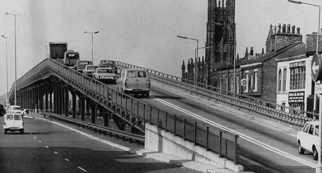
Construction of “The Mancunian Way” began in the 1960s, when Manchester was seeking answers to the explosive growth in traffic, active motorisation, and the need for post-war urban renewal. It was a period when urban planning in Great Britain sharply changed course: moving away from classic city streets towards functionalist modernism, where transport flows were expected to move quickly, rationally, and without obstruction. In the mid-20th century, Manchester strove to enter a new era of infrastructure breakthroughs. “The Mancunian Way” became the embodiment of this vision — the most ambitious road project in the city at that time.
Building a multi-level road in a densely built-up city centre was a significant technical challenge. The flyover passed above existing streets without interrupting the traffic below. This allowed for the creation of an additional transport corridor without widening the roads on the ground — a solution that was considered maximally modern and effective at the time.
The project was developed under the influence of European modernism and the American concept of the “freeway”. Key features included:
- linear high-speed routes rapidly connecting districts;
- multi-level junctions designed to minimise traffic lights and congestion;
- separation of flows — distinct lanes for transit and local traffic;
- maximum concrete and minimum decoration, adhering to the functionalist aesthetic of the era.
At that moment, it looked like a solution to the transport crisis and a transition to the concept of the modern metropolis, where the city adapts to the car, rather than the other way around.
“The Mancunian Way” was intended to be part of a wider system — a high-speed ring road around the centre. For the 1960s, such an idea was revolutionary: the city was essentially gaining its own “express frame,” speeding up movement between industrial, residential, and commercial zones.
New engineering solutions were applied to the flyover: **prestressed concrete**, which allowed for longer spans, special noise-dampening barriers, as well as structures adapted for future expansion and drainage elements that were novel for British urban motorways.
For Manchester, this was not merely road construction — it was a breakthrough in technological thinking.
Along with the improvement of the transport system, the city acquired a new urban reality. To realise the project, dozens of historic buildings were demolished, the familiar structure of neighbourhoods was altered, and parts of the territory were effectively turned into a transit corridor. The authorities saw this as modernisation, but for many citizens, it became a symbol of the loss of authenticity.
In the 1960s, “The Mancunian Way” became not just a road — it became a cultural marker of the era, when the city was choosing between historical heritage and rapid modernisation.
Accidents, Collapses, and a Reputation as a Dangerous Road

Although the project was presented as a technological breakthrough, the motorway very quickly gained a reputation as problematic. High kerbs, sharp corners, high speeds, and minimal protective barriers turned the flyover into one of the most accident-prone stretches of road in Great Britain. Drivers often joked that navigating “The Mancunian Way” required not so much driving skill as a bit of luck — especially during rush hour or in wet weather.
The most alarming event was the incident in 2015, when, following torrential rain, a section of “The Mancunian Way” structure collapsed. Traffic had to be closed for months, the city incurred millions in losses, and experts began talking about the dilapidated state of the structure and the lack of systemic investment in modernisation. This case became a wake-up call for Manchester: infrastructure built half a century ago no longer meets modern safety requirements or new climate risks, particularly the increasingly frequent abnormal rainfall.
Subsequently, other incidents occurred — serious road traffic accidents, fragments of the structure falling during bad weather, and prolonged traffic blockages that paralysed the city centre. Some residents even dubbed the motorway “Manchester’s Worst Shortcut”, hinting at its paradoxical nature: a road created to speed up movement often became the cause of jams, chaos, and diversions. For many Mancunians, “The Mancunian Way” transformed into a symbol of infrastructure ageing — a reminder that even the most ambitious projects require constant renewal if they are to remain safe and efficient.
“The Mancunian Way” and the Conflict Between Car and Pedestrian Culture
Disputes surrounding “The Mancunian Way” have not subsided for decades. For some, it is a necessary transport hub without which the city would grind to a halt. For others, it is an example of the mistakes of 1960s urbanism, when cars were placed above people.
The flyover literally divides districts: Hulme, Ardwick, Piccadilly. Pedestrians are forced to use inconvenient crossings, and communities complain about noise, dust, and vibrations.
Architects and activists have long been discussing the transformation of “The Mancunian Way”:
- turning it into a green corridor;
- moving traffic underground;
- partially dismantling it, as was done in Seattle or Seoul;
- modernising it to “smart motorway” standards.
Despite numerous concepts, there is no solution as yet. However, discussions about what Manchester’s infrastructure should look like in the 21st century are intensifying.
Innovations and the Future: Will “The Mancunian Way” Become Part of the “Smart City”?
Although “The Mancunian Way” is perceived as a relic of the past, in recent years the city has been actively testing elements of “smart” urbanism on it. Flow sensors are being installed here, traffic is analysed in real-time, and systems for forecasting congestion and accidents are being tested.
After 2016, when Manchester launched the large-scale “CityVerve” project, the motorway became part of IoT experiments:
- sensors measure pollution levels;
- cameras record peak loads;
- algorithms model safe routes;
- options for installing noise-absorbing structures and solar panels are being considered.
Officials and urbanists aim to transform “The Mancunian Way” into a road space that works not against the city, but together with it — taking into account the needs of residents, the environment, and modern technologies.
In the future, the motorway could become a testing ground for driverless transport, a green flyover, or an innovative corridor with energy-saving systems. There are many options — and for the first time in decades, the city is ready to consider each of them.
“The Mancunian Way” is a controversial, dangerous, sometimes inconvenient, yet simultaneously iconic part of Manchester. It reflects its history of modernisation, the mistakes of past decades, and the ambitions of the future. The motorway has long since transcended its transport function, becoming a mirror of a constantly changing city.
What its fate will be — dismantling, reconstruction, or a complete reimagining — depends on how Manchester wishes to see itself in the 21st century.