

Bus 231 in Manchester links Piccadilly Gardens and Ashton-under-Lyne Interchange. The route is 0.0 km long with 65 stops, and the official schedule from Transport for Greater Manchester (TfGM) puts the full trip at about 65 minutes. On a weekday it runs 35 trips in one direction.
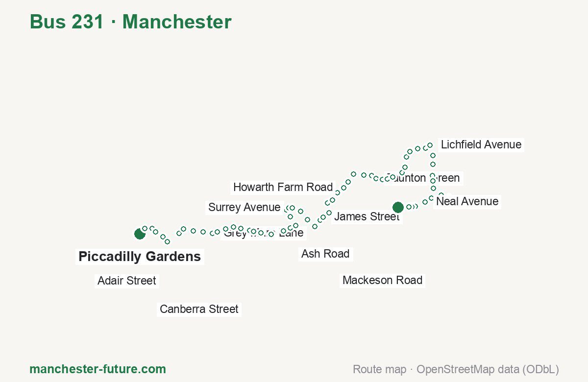
Route at a glance
| Mode | Bus |
|---|---|
| Route number | 231 |
| City | Manchester |
| Operator | Transport for Greater Manchester (TfGM) |
| Start → end | Piccadilly Gardens → Ashton-under-Lyne Interchange |
| End → start | Ashton-under-Lyne Interchange → Piccadilly Gardens |
| Route length | 0.0 km / 0.0 km in the opposite direction |
| Number of stops | 65 / 65 in the opposite direction |
| Travel time | about 65 minutes |
| Trips per day | 35 on weekdays one way |
| Frequency | peak 21–30 · midday 30 |
| First / last trip from «Piccadilly Gardens» | 06:02 / 22:52 |
| First / last trip from «Ashton-under-Lyne Interchange» | 05:29 / 22:25 |
| Fare | 2.00 £ (fare in effect since 5 January 2025) |
| Updated | August 22, 2026 |
Route of Bus 231
Outbound: Piccadilly Gardens → Ashton-under-Lyne Interchange
This direction has 65 stops. The route passes Faraday Street, Schofield Street, Sandy Lane, Bristol Avenue. The full list of stops in order is below.
| No. | Stop | From start | Note |
|---|---|---|---|
| 1 | Piccadilly Gardens | 0.0 km | Terminus |
| 2 | Faraday Street | 0.0 km | |
| 3 | Jersey Street | 0.0 km | |
| 4 | Laystall Street | 0.0 km | |
| 5 | Old Mill Street | 0.0 km | |
| 6 | Adair Street | 0.0 km | |
| 7 | Carruthers Street | 0.0 km | |
| 8 | Holt Town Metrolink Stop | 0.0 km | |
| 9 | Councillor Street | 0.0 km | |
| 10 | Etihad Stadium | 0.0 km | |
| 11 | Grey Mare Lane | 0.0 km | |
| 12 | Velopark Metrolink Stop | 0.0 km | |
| 13 | City Football Academy | 0.0 km | |
| 14 | North Road | 0.0 km | |
| 15 | Clayton Hall Metrolink Stop | 0.0 km | |
| 16 | Canberra Street | 0.0 km | |
| 17 | Schofield Street | 0.0 km | |
| 18 | Aldi | 0.0 km | |
| 19 | Edge Lane Metrolink Stop | 0.0 km | |
| 20 | Sunnybank Road | 0.0 km | |
| 21 | Ash Road | 0.0 km | |
| 22 | Fiveways Byron Avenue | 0.0 km | |
| 23 | Springfield Road | 0.0 km | |
| 24 | St Martin’s Church | 0.0 km | |
| 25 | Greenside Lane | 0.0 km | |
| 26 | Surrey Avenue | 0.0 km | |
| 27 | Shrewsbury Road | 0.0 km | |
| 28 | Clough Road | 0.0 km | |
| 29 | Medlock Street | 0.0 km | |
| 30 | Thornhill Road | 0.0 km | |
| 31 | James Street | 0.0 km | |
| 32 | Sandy Lane | 0.0 km | |
| 33 | Littlemoss Road | 0.0 km | |
| 34 | Cryer Street | 0.0 km | |
| 35 | Laurus Ryecroft | 0.0 km | |
| 36 | Howarth Farm Road | 0.0 km | |
| 37 | Back Lane | 0.0 km | |
| 38 | Daisy Nook Country Park | 0.0 km | |
| 39 | Newmarket Grove | 0.0 km | |
| 40 | Downing Street | 0.0 km | |
| 41 | Taunton Green | 0.0 km | |
| 42 | Taunton Road | 0.0 km | |
| 43 | Oldham Road | 0.0 km | |
| 44 | Tiverton Place | 0.0 km | |
| 45 | Wood Lane | 0.0 km | |
| 46 | Timperley Road | 0.0 km | |
| 47 | Bristol Avenue | 0.0 km | |
| 48 | Carlisle Crescent | 0.0 km | |
| 49 | Newstead Avenue | 0.0 km | |
| 50 | Exeter Drive | 0.0 km | |
| 51 | Lichfield Avenue | 0.0 km | |
| 52 | Temple | 0.0 km | |
| 53 | St Christopher’s Road | 0.0 km | |
| 54 | King’s Road | 0.0 km | |
| 55 | Palace Road | 0.0 km | |
| 56 | Mackeson Road | 0.0 km | |
| 57 | Tameside General Hospital | 0.0 km | |
| 58 | Tameside General Hospital | 0.0 km | |
| 59 | Tameside General Hospital | 0.0 km | |
| 60 | Princess Street | 0.0 km | |
| 61 | Neal Avenue | 0.0 km | |
| 62 | Crickets Lane | 0.0 km | |
| 63 | Glebe Street | 0.0 km | |
| 64 | Swan Street | 0.0 km | |
| 65 | Ashton-under-Lyne Interchange | 0.0 km | Terminus |
Inbound: Ashton-under-Lyne Interchange → Piccadilly Gardens
This direction has 65 stops. The route passes Wimpole Street, Bristol Avenue, James Street, Schofield Street. The full list of stops in order is below.
| No. | Stop | From start | Note |
|---|---|---|---|
| 1 | Ashton-under-Lyne Interchange | 0.0 km | Terminus |
| 2 | Wimpole Street | 0.0 km | |
| 3 | Crickets Lane | 0.0 km | |
| 4 | Neal Avenue | 0.0 km | |
| 5 | Tameside General Hospital | 0.0 km | |
| 6 | Tameside General Hospital | 0.0 km | |
| 7 | Tameside General Hospital | 0.0 km | |
| 8 | Mackeson Road | 0.0 km | |
| 9 | Palace Road | 0.0 km | |
| 10 | Hurst Cross | 0.0 km | |
| 11 | St Christopher’s Road | 0.0 km | |
| 12 | Temple | 0.0 km | |
| 13 | Lichfield Avenue | 0.0 km | |
| 14 | Exeter Drive | 0.0 km | |
| 15 | Newstead Avenue | 0.0 km | |
| 16 | Carlisle Crescent | 0.0 km | |
| 17 | Bristol Avenue | 0.0 km | |
| 18 | Timperley Road | 0.0 km | |
| 19 | Gambrel Bank Road | 0.0 km | |
| 20 | Tiverton Place | 0.0 km | |
| 21 | Oldham Road | 0.0 km | |
| 22 | Taunton Road | 0.0 km | |
| 23 | Taunton Green | 0.0 km | |
| 24 | Downing Street | 0.0 km | |
| 25 | Newmarket Grove | 0.0 km | |
| 26 | Daisy Nook Country Park | 0.0 km | |
| 27 | Back Lane | 0.0 km | |
| 28 | Howarth Farm Road | 0.0 km | |
| 29 | Laurus Ryecroft | 0.0 km | |
| 30 | Cryer Street | 0.0 km | |
| 31 | Sandy Lane | 0.0 km | |
| 32 | James Street | 0.0 km | |
| 33 | Oldham Street | 0.0 km | |
| 34 | Market Street | 0.0 km | |
| 35 | Clough Road | 0.0 km | |
| 36 | Shrewsbury Road | 0.0 km | |
| 37 | Surrey Avenue | 0.0 km | |
| 38 | Greenside Lane | 0.0 km | |
| 39 | Springfield Road | 0.0 km | |
| 40 | Fiveways Byron Avenue | 0.0 km | |
| 41 | Ash Road | 0.0 km | |
| 42 | Sunnybank Road | 0.0 km | |
| 43 | Buxton Lane | 0.0 km | |
| 44 | Edge Lane Metrolink Stop | 0.0 km | |
| 45 | Dargai Street | 0.0 km | |
| 46 | Aldi | 0.0 km | |
| 47 | Schofield Street | 0.0 km | |
| 48 | Clayton Hall Metrolink Stop | 0.0 km | |
| 49 | North Road | 0.0 km | |
| 50 | City Football Academy | 0.0 km | |
| 51 | Velopark Metrolink Stop | 0.0 km | |
| 52 | Alan Turing Way | 0.0 km | |
| 53 | Etihad Stadium | 0.0 km | |
| 54 | Councillor Street | 0.0 km | |
| 55 | Hillkirk Street | 0.0 km | |
| 56 | Holt Town Metrolink Stop | 0.0 km | |
| 57 | Harding Street | 0.0 km | |
| 58 | Tutbury Street | 0.0 km | |
| 59 | Every Street | 0.0 km | |
| 60 | Old Mill Street | 0.0 km | |
| 61 | Ducie Street | 0.0 km | |
| 62 | Rochdale Canal | 0.0 km | |
| 63 | Jersey Street | 0.0 km | |
| 64 | Warwick Street | 0.0 km | |
| 65 | Piccadilly Gardens | 0.0 km | Terminus |
Schedule and frequency
According to the official schedule from Transport for Greater Manchester (TfGM), the route runs 35 trips in one direction on a weekday.
| Direction | Weekdays | Weekends and holidays |
|---|---|---|
| From «Piccadilly Gardens» | 06:02 — 22:52 | — — — |
| From «Ashton-under-Lyne Interchange» | 05:29 — 22:25 | — — — |
Frequency calculated from the departure table: in the morning peak buses run every 21–30 minutes, most often every 30; midday every 30 minutes; in the afternoon peak every 10–45.
Fare and payment
A single ride costs 2.00 £ — fare in effect since 5 January 2025. The same fare applies to buses in Greater Manchester.
A single bus journey costs £2.00. It is a hopper fare: unlimited bus journeys across the Bee Network within one hour of the first tap cost nothing extra. A day ticket is £5.00. Transfers within 60 minutes are free. Transfers within the hopper hour are free across all Bee Network buses.
Frequently asked questions
How much does a ride on bus 231 cost?
2.00 £ for a single ride — fare in effect since 5 January 2025.
When do the first and last trips run?
From Piccadilly Gardens the first is at 06:02 and the last at 22:52. From Ashton-under-Lyne Interchange they are 05:29 and 22:25.
How long does the trip from Piccadilly Gardens to Ashton-under-Lyne Interchange take?
About 65 minutes end to end — the median of full trips in the official schedule.
How many stops does the route have?
65 outbound and 65 inbound according to the official GTFS feed. The two lists do not match exactly.
Does bus 231 run on weekends?
Yes, the route runs every day, with a separate weekend schedule.
Every route number with its termini, operating hours and travel time is collected in the Manchester buses overview.
Data current as of August 22, 2026. Schedule and termini — Transport for Greater Manchester (TfGM). Fares — Transport for Greater Manchester. Stop list, schedule and route geometry come from the official GTFS feed (Bus Open Data Service (BODS)).