

Bus 17 in Manchester links Shudehill Interchange and Edenfield Road. The route is 0.0 km long with 85 stops, and the official schedule from Transport for Greater Manchester (TfGM) puts the full trip at about 80 minutes. On a weekday it runs 104 trips in one direction, and 57 on a weekend day.
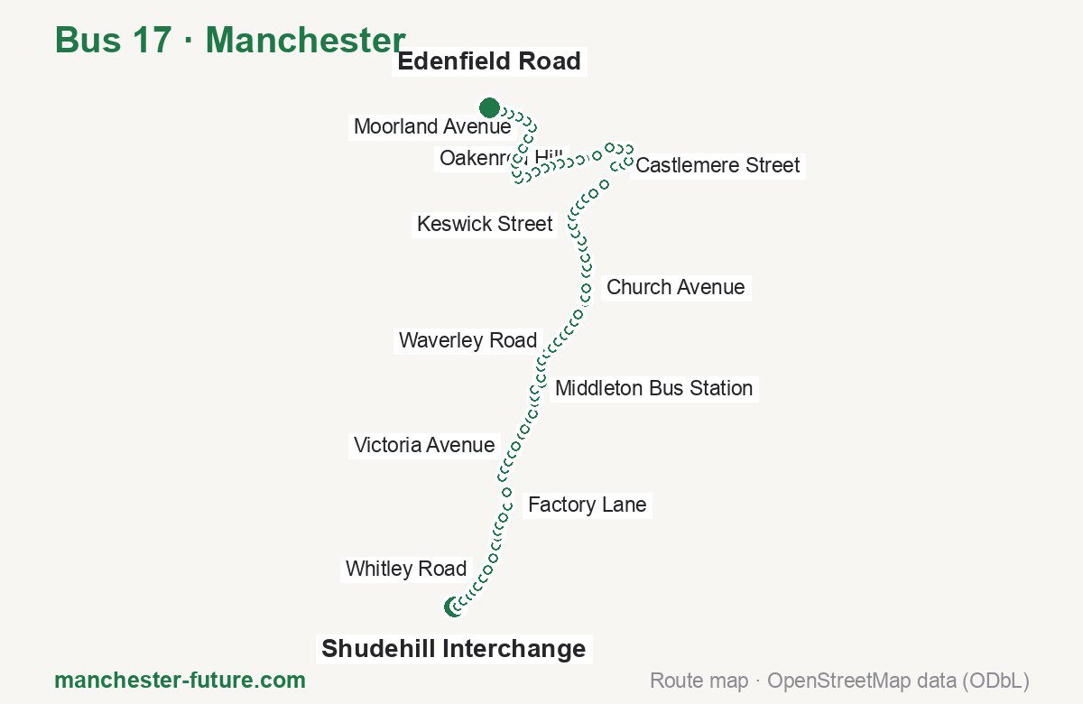
Route at a glance
| Mode | Bus |
|---|---|
| Route number | 17 |
| City | Manchester |
| Operator | Transport for Greater Manchester (TfGM) |
| Start → end | Shudehill Interchange → Edenfield Road |
| End → start | Edenfield Road → Shudehill Interchange |
| Route length | 0.0 km / 0.0 km in the opposite direction |
| Number of stops | 85 / 83 in the opposite direction |
| Travel time | about 80 minutes |
| Trips per day | 104 on weekdays, 57 on weekends one way |
| Frequency | peak 2–10 · midday 8–10 · weekend 15–30 |
| First / last trip from «Shudehill Interchange» | 04:25 / 23:42 |
| First / last trip from «Edenfield Road» | 00:04 / 23:34 |
| Fare | 2.00 £ (fare in effect since 5 January 2025) |
| Updated | August 22, 2026 |
Route of Bus 17
Outbound: Shudehill Interchange → Edenfield Road
This direction has 85 stops. The route passes Hanover Street, Victoria Avenue, Thornham Lane, Hopwood Hall College. The full list of stops in order is below.
| No. | Stop | From start | Note |
|---|---|---|---|
| 1 | Shudehill Interchange | 0.0 km | Terminus |
| 2 | Hanover Street | 0.0 km | |
| 3 | Marshall Street | 0.0 km | |
| 4 | Clive Street | 0.0 km | |
| 5 | Peary Street | 0.0 km | |
| 6 | Livesey Street | 0.0 km | |
| 7 | Osborne Street | 0.0 km | |
| 8 | Whitley Road | 0.0 km | |
| 9 | Paget Street | 0.0 km | |
| 10 | Park View | 0.0 km | |
| 11 | Lathbury Road | 0.0 km | |
| 12 | Kingsbridge Road | 0.0 km | |
| 13 | Ash Street | 0.0 km | |
| 14 | Oak Bank | 0.0 km | |
| 15 | Factory Lane | 0.0 km | |
| 16 | Parkmount Road | 0.0 km | |
| 17 | Old Road | 0.0 km | |
| 18 | Charlestown Road | 0.0 km | |
| 19 | Lion Brow | 0.0 km | |
| 20 | Dam Head Medical Centre | 0.0 km | |
| 21 | Hilldale Avenue | 0.0 km | |
| 22 | Victoria Avenue | 0.0 km | |
| 23 | Mossway | 0.0 km | |
| 24 | Mainway | 0.0 km | |
| 25 | Woodlands Way | 0.0 km | |
| 26 | Hall Drive | 0.0 km | |
| 27 | Alkrington Hall Road North | 0.0 km | |
| 28 | Mill Fold Road | 0.0 km | |
| 29 | Middleton Bus Station | 0.0 km | |
| 30 | Middleton Arena | 0.0 km | |
| 31 | Cemetery Street | 0.0 km | |
| 32 | New Lane | 0.0 km | |
| 33 | Cleworth Road | 0.0 km | |
| 34 | Hollin Lane | 0.0 km | |
| 35 | Nowell Road | 0.0 km | |
| 36 | Waverley Road | 0.0 km | |
| 37 | Stanycliffe Lane | 0.0 km | |
| 38 | Cardinal Langley High School | 0.0 km | |
| 39 | Hopwood Hall College | 0.0 km | |
| 40 | Manchester Golf Club | 0.0 km | |
| 41 | Slattocks | 0.0 km | |
| 42 | Thornham Lane | 0.0 km | |
| 43 | Church Avenue | 0.0 km | |
| 44 | Chesham Avenue | 0.0 km | |
| 45 | Thornham New Road | 0.0 km | |
| 46 | Trows Lane | 0.0 km | |
| 47 | Vicarage Road North | 0.0 km | |
| 48 | Queensway | 0.0 km | |
| 49 | Milne Street | 0.0 km | |
| 50 | Keswick Street | 0.0 km | |
| 51 | Abbott Street | 0.0 km | |
| 52 | Royal Toby Hotel | 0.0 km | |
| 53 | St Aidan’s Church | 0.0 km | |
| 54 | Tesco | 0.0 km | |
| 55 | Roch Valley Way | 0.0 km | |
| 56 | Highfield Hospital | 0.0 km | |
| 57 | Castlemere Street | 0.0 km | |
| 58 | Milkstone Road | 0.0 km | |
| 59 | Moore Street | 0.0 km | |
| 60 | Rochdale Interchange | 0.0 km | |
| 61 | The Esplanade | 0.0 km | |
| 62 | Hopwood Hall College | 0.0 km | |
| 63 | Mellor Street | 0.0 km | |
| 64 | Oakenrod Hill | 0.0 km | |
| 65 | Claremont Road | 0.0 km | |
| 66 | Rochdale Cemetery | 0.0 km | |
| 67 | Fieldhead Avenue | 0.0 km | |
| 68 | Woodlands Avenue | 0.0 km | |
| 69 | Broadhalgh Road | 0.0 km | |
| 70 | Meadowcroft Lane | 0.0 km | |
| 71 | Wood Top Avenue | 0.0 km | |
| 72 | Arnside Drive | 0.0 km | |
| 73 | Bamford Post Office | 0.0 km | |
| 74 | War Office Road | 0.0 km | |
| 75 | Belgium Street | 0.0 km | |
| 76 | Springbank Lane | 0.0 km | |
| 77 | Clay Lane | 0.0 km | |
| 78 | Moorland Avenue | 0.0 km | |
| 79 | Elmsfield Avenue | 0.0 km | |
| 80 | Shawfield Lane | 0.0 km | |
| 81 | Norden Village | 0.0 km | |
| 82 | Hutchinson Road | 0.0 km | |
| 83 | White Lion | 0.0 km | |
| 84 | Norden Close | 0.0 km | |
| 85 | Edenfield Road | 0.0 km | Terminus |
Inbound: Edenfield Road → Shudehill Interchange
This direction has 83 stops. The route passes Norden Close, Half Acre Drive, Trows Lane, Mainway. The full list of stops in order is below.
| No. | Stop | From start | Note |
|---|---|---|---|
| 1 | White Lion | 0.0 km | Terminus |
| 2 | Norden Close | 0.0 km | |
| 3 | Edenfield Road | 0.0 km | |
| 4 | Hutchinson Road | 0.0 km | |
| 5 | Norden Village | 0.0 km | |
| 6 | Shawfield Lane | 0.0 km | |
| 7 | Elmsfield Avenue | 0.0 km | |
| 8 | Grimes Street | 0.0 km | |
| 9 | Bagslate Moor Lane | 0.0 km | |
| 10 | Clay Lane | 0.0 km | |
| 11 | Springbank Lane | 0.0 km | |
| 12 | Belgium Street | 0.0 km | |
| 13 | Norden Road | 0.0 km | |
| 14 | Bamford Post Office | 0.0 km | |
| 15 | Sandhole Lane | 0.0 km | |
| 16 | Wood Top Avenue | 0.0 km | |
| 17 | Meadowcroft Lane | 0.0 km | |
| 18 | Broadhalgh Road | 0.0 km | |
| 19 | Woodlands Avenue | 0.0 km | |
| 20 | Fieldhead Avenue | 0.0 km | |
| 21 | Rochdale Cemetery | 0.0 km | |
| 22 | Half Acre Drive | 0.0 km | |
| 23 | Claremont Road | 0.0 km | |
| 24 | Oakenrod Hill | 0.0 km | |
| 25 | Mellor Street | 0.0 km | |
| 26 | Holmes Street | 0.0 km | |
| 27 | The Esplanade | 0.0 km | |
| 28 | Rochdale Interchange | 0.0 km | |
| 29 | Moore Street | 0.0 km | |
| 30 | Milkstone Road | 0.0 km | |
| 31 | Castlemere Street | 0.0 km | |
| 32 | Tweedale Street | 0.0 km | |
| 33 | Highfield Hospital | 0.0 km | |
| 34 | Tesco | 0.0 km | |
| 35 | St Aidan’s Church | 0.0 km | |
| 36 | Gipsy Lane | 0.0 km | |
| 37 | Abbott Street | 0.0 km | |
| 38 | Keswick Street | 0.0 km | |
| 39 | Milne Street | 0.0 km | |
| 40 | Vicarage Road North | 0.0 km | |
| 41 | Mount Street | 0.0 km | |
| 42 | Trows Lane | 0.0 km | |
| 43 | Thornham New Road | 0.0 km | |
| 44 | Chesham Avenue | 0.0 km | |
| 45 | Church Avenue | 0.0 km | |
| 46 | Thornham Lane | 0.0 km | |
| 47 | Manchester Golf Club | 0.0 km | |
| 48 | Hopwood Hall College | 0.0 km | |
| 49 | Cardinal Langley High School | 0.0 km | |
| 50 | Stanycliffe Lane | 0.0 km | |
| 51 | Waverley Road | 0.0 km | |
| 52 | Nowell Road | 0.0 km | |
| 53 | Hollin Lane | 0.0 km | |
| 54 | New Lane | 0.0 km | |
| 55 | Cemetery Street | 0.0 km | |
| 56 | Eastway | 0.0 km | |
| 57 | Middleton Bus Station | 0.0 km | |
| 58 | Mill Fold Road | 0.0 km | |
| 59 | Alkrington Hall Road North | 0.0 km | |
| 60 | Hall Drive | 0.0 km | |
| 61 | Woodlands Way | 0.0 km | |
| 62 | Mainway | 0.0 km | |
| 63 | Mossway | 0.0 km | |
| 64 | Victoria Avenue | 0.0 km | |
| 65 | Hilldale Avenue | 0.0 km | |
| 66 | Dam Head Medical Centre | 0.0 km | |
| 67 | Lion Brow | 0.0 km | |
| 68 | Charlestown Road | 0.0 km | |
| 69 | Old Road | 0.0 km | |
| 70 | Parkmount Road | 0.0 km | |
| 71 | Factory Lane | 0.0 km | |
| 72 | Oak Bank | 0.0 km | |
| 73 | Ash Street | 0.0 km | |
| 74 | Kingsbridge Road | 0.0 km | |
| 75 | Lathbury Road | 0.0 km | |
| 76 | Queens Road | 0.0 km | |
| 77 | Paget Street | 0.0 km | |
| 78 | Whitley Road | 0.0 km | |
| 79 | Osborne Street | 0.0 km | |
| 80 | Peary Street | 0.0 km | |
| 81 | Clive Street | 0.0 km | |
| 82 | Marshall Street | 0.0 km | |
| 83 | Shudehill Interchange | 0.0 km | Terminus |
Schedule and frequency
According to the official schedule from Transport for Greater Manchester (TfGM), the route runs 104 trips in one direction on a weekday, and 57 on a weekend day.
| Direction | Weekdays | Weekends and holidays |
|---|---|---|
| From «Shudehill Interchange» | 04:25 — 23:42 | 05:42 — 23:42 |
| From «Edenfield Road» | 00:04 — 23:34 | 00:06 — 23:36 |
Frequency calculated from the departure table: in the morning peak buses run every 2–10 minutes, most often every 10; midday every 8–10 minutes; in the afternoon peak every 10; on weekends every 15–30 minutes.
Fare and payment
A single ride costs 2.00 £ — fare in effect since 5 January 2025. The same fare applies to buses in Greater Manchester.
A single bus journey costs £2.00. It is a hopper fare: unlimited bus journeys across the Bee Network within one hour of the first tap cost nothing extra. A day ticket is £5.00. Transfers within 60 minutes are free. Transfers within the hopper hour are free across all Bee Network buses.
Frequently asked questions
How much does a ride on bus 17 cost?
2.00 £ for a single ride — fare in effect since 5 January 2025.
When do the first and last trips run?
From Shudehill Interchange the first is at 04:25 and the last at 23:42. From Edenfield Road they are 00:04 and 23:34.
How long does the trip from Shudehill Interchange to Edenfield Road take?
About 80 minutes end to end — the median of full trips in the official schedule.
How many stops does the route have?
85 outbound and 83 inbound according to the official GTFS feed. The two lists do not match exactly.
Does bus 17 run on weekends?
Yes. On weekends and holidays there are 57 trips in one direction, running from Shudehill Interchange between 05:42 and 23:42.
Every route number with its termini, operating hours and travel time is collected in the Manchester buses overview.
Data current as of August 22, 2026. Schedule and termini — Transport for Greater Manchester (TfGM). Fares — Transport for Greater Manchester. Stop list, schedule and route geometry come from the official GTFS feed (Bus Open Data Service (BODS)).